


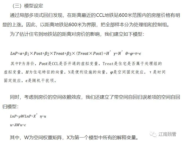
先来学习南开大学区域经济应用实验室的一篇翻译文章:
新建地铁对私人住宅价值的影响:空间双重差分模型
文献来源:Diao M, Leonard D, Sing TF. Spatial-Difference-in-Differences Models for Impact of New Mass Rapid Transit Line on Private Housing Values[J].Regional Science & Urban Economics,2017,67.
摘要:本研究利用新加坡的新建地铁环线(CCL)作为一项自然实验,测量城市轨道交通网络对非有地私宅价值的影响。我们使用网络距离测量和局部多项式回归方法来识别CCL影响区域,在处理区域和控制区域之间的房价梯度上显示出不连续性。然后,我们估计了一个空间双重差分模型,证实了CCL开通前后两个区域的房价变化的空间自相关,并控制了其他因素比如住房的属性、当地的便利设施、空间和时间的固定效应。我们发现,在距离新的CCL站的600米的范围内,房价上涨约7.8%。我们还发现在CCL线开通前1年出现了显著的“预期”效应,其影响在CCL开通之前逐渐缩小。结果表明,处理地区和控制地区之间的相互依赖的空间结构是相关的,如果忽视这一点,可能会高估新运输线路对房屋价值的影响。
是否觉得不是很难,但有新鲜?DID设定容易,然后就是空间计量经济学模型的选择了,Matlab,Stata,R都可以选择。Stata的使用参考前一篇推文:
区域经济研究方法:ArcGIS联手Stata做可视化空间计量经济学建模
比如这篇A spatial Diff-in-Diff analysis of the impact of sugarcane producion on respiratory diseases选择Matlab的写道:
We based our estimates on Elhorst's routine for spatial panel data models (Elhorst, 2010b,a). Elhorst uses Maximum Likelihood (ML) because the number of studies considering Instrumental Vari-ables/Generalized Method of Moments (IV/GMM) estimators of spatial panel data models is still rela-tively sparse. One exception is Kelejian et al. (2006), who used IV to estimate a spatial lag model with time-period xed effects. They point out that the model cannot be combined with a spatial weights matrix with non-diagonal elements equal to 1/(N-1). In this situation, the spatially lagged dependent is asymptotically proportional and thus collinear with the time-period xed effects, as N goes to innity.Elhorst (2010a) provides Matlab routines to estimate spatial panel data models, including the bias correction procedure proposed by Lee and Yu (2010) if the spatial panel data model contain spatial and/or time-period xed effects, the direct and indirect eects estimates of the explanatory variables proposed by LeSage and Pace (2009), and a selection framework to determine which spatial panel data model best describes the data.
Elhorst老先生的官网有Matlab包,还有北大教授的jihai.m,可以去学习:
https://spatial-panels.com/software/
中文也有一些空间倍差法SDID,或称双重差分空间自回归什么的,CNKI查询。
区域经济研究方法:ArcGIS联手Stata做可视化空间计量经济学建模
区域经济研究方法Master Program:根据经纬度Stata制空间权重矩阵代码数据
基于ArcGlobe的全球移动电话,中国、美国、“一带一路”沿线夜间灯光可视化分布
空间计量及Stata、ArcGIS及Matlab、GeoDa软件应用
动态空间面板模型教程(一文读懂动态面板空间spregdpd操作应用)
一文读懂空间计量及stata应用(附lr检验、空间可视化、权重矩阵、检验、模型dofile等)
空间计量及应用SPATIAL AUTOREGRESSIVE MODELS USING STATA(一)
根据经纬度Stata制空间权重矩阵代码数据:附空间计量经济学软件代码与参考文献